
WARMER THAN AVERAGE PAST WEEK
Over the last week, temperatures have consistently rose to warmer than average values in Philadelphia and surrounding areas.
From a high of 45 last Wednesday (Jan. 18) to a high of 50 on Sunday and even a high of 46 Monday, the temperatures have been rather mild. To be fair, Monday actually felt pretty chilly due to high winds and an afternoon cool down with the Nor’easter (the high temperature hit just before 2 a.m.).
The average this time of year isn’t too much colder, 40 degrees in Philly. But the warmer than average temperatures have been just enough to ensure almost our entire region stuck to rain during the Nor’easter passage on Monday, which happened to come exactly one year after a MUCH snowier Nor’easter passage in 2016.
A QUICK CLIMB FOR OUR AFTERNOON HIGHS
Over the next two days, temperatures will remain above average. In fact, they’re expected to take a fairly nice jump for Wednesday and Thursday. Take a look at the temperature anomaly map for early afternoon Wednesday, based off one model. The reds indicate warmer than average air temperatures.
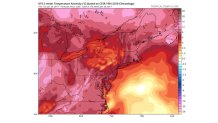
The NBC10 First Alert Team is forecasting a high of 55 in Philadelphia Wednesday and the same high temperature for Thursday. Mid 50s are likely through parts of Delaware and New Jersey as well.
We’ll see plenty of sunshine Wednesday, but Thursday will be accompanied by more clouds and some morning light rain.
Local
Breaking news and the stories that matter to your neighborhood.
THE RETURN TO TYPICAL JANUARY TEMPERATURES
Remember, for this time of year, a high temperature in Philadelphia of 40 degrees is average. So while it won’t be bitterly cold when we drop this weekend, it will feel quite a bit colder than the mild conditions we’ve been experiencing.
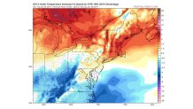
We’re forecasting high temperatures right around the upper 30s to 40 degrees beginning Saturday. Actually, those seasonal conditions last right into next week! Here’s the temperature anomaly map again, but now looking to Saturday afternoon. Notice our region is partially in the white (right at average). Some spots are shaded in light yellow, which indicates temperatures just barely above average.
Overnight lows will return to average as well. Over the last several days, low temperatures remained above freezing throughout the nights and mornings. That’s not going to be the case much longer. Chilly nights return for the weekend, with lows forecast in the mid to upper 20s for Philadelphia.
We’ll stay dry, too, this weekend. It appears that trend may hold tight through the next work week!
