
Weather forecasters are under pressure every day of the year. The weather on any given day may not be important to you, but it’s surely important to somebody. And that person will be mightily disappointed (to put it mildly) if we get it wrong for that day. Weekends are generally more important than weekdays for most people, which is why we highlight them in every 7-day forecast on NBC10.
And then there are the holiday weekends: often three days of leisure, when the most important activities are outdoors. The three biggest are during the “summer season”: Memorial Day, 4th of July, and Labor Day. Each of the three has their own challenges. I’ll abbreviate them for the sake of simplicity: MD, 4J, and LD.
Memorial Day Weekend (MD)
This is the one most likely to have bad weather for outdoor activities, such as barbecues and the beach. First of all, it’s still May, and average high temperatures are only in the 70s, and record low temperatures are way down in the 40s (even 30s in some suburbs). We have to be concerned about cold fronts coming down from Canada PLUS “back-door” cold fronts that come in from New England. I’ve seen MD weekend forecasts “bust” by more than 20 degrees only a couple of days out, as warm air overhead gets pushed westward by the back-door front. Ouch!
4th of July (4J)
This one is right in the middle of summer, so it has the best chance to be hot and humid. The average high is 84 in Phila, and back-door fronts become extremely rare. The biggest weather problems are usually extreme heat or big thunderstorms. The heat part is the easiest to predict, but, as usual, thunderstorms can come right on schedule or pop up out of nowhere. Boaters can sometimes be put in danger by an unexpected severe thunderstorm. July is historically our wettest month of the year, so there’s usually a chance of storms for at least one of the three weekend days.
Labor Day (LD)
Local
Breaking news and the stories that matter to your neighborhood.


The average high temperature is about 80 degrees for LD. We’re less likely to get extreme heat or heavy thunderstorms than 4J, but there is potentially an even bigger problem: LD occurs during the historical PEAK of Hurricane Season. The threat of a hurricane is practically zero for MD, and very low for 4J, but the peak of hurricane season is a big spike that hits during September. I’ve seen some pretty scary close calls in this area.
Hurricane Edouard in 1996 was the scariest. The predicted track was right up Delaware Bay on LD weekend! And Edouard was a powerful Category 4 hurricane. Hurricane Watches and Tropical Storm Warnings were actually issued for the Delaware and New Jersey coasts. Fortunately, Edouard curved out to sea, so you probably don’t even remember the name. But meteorologists in this area do. It had “worst-case scenario” written all over it, with a predicted track close to what Sandy did 16 years later. Except Sandy had 75 mph winds, and Edouard had 120 mph maximum winds not far off the mid-Atlantic coast.
TO SWIM OR NOT TO SWIM
We can pretty much guarantee that the ocean is going to be cold on MD weekend. The only question is how cold. Here are the current water temperatures, followed by the average for this week, and then the averages for 4J and MD:

So, you’ll notice that LD weekend typically has a warmer ocean than 4J weekend. Not many people realize that. It takes longer for the ocean to warm than the land, so the warmest water temperatures come much later than the warmest land temperatures. A sea breeze off a 55 degree ocean is a LOT colder than one off a 72 degree ocean. That’s why I’ve always liked to vacation in August or even September, rather than July. Shhhh….don’t tell anyone….
THE FORECAST (FINALLY!)
(Friday is sunny and beautiful, for those folks who can get out early. High 75)
SATURDAY
The first part of the holiday weekend is going to be the easiest part of the forecast. A large area of HIGH pressure will be moving right over our area, so that means a good bet for sunshine and cool temperatures. Here’s one computer model for Saturday morning (the others are similar)
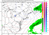
- Phila- sunny and cool. High 68. Chance of rain is near 0%
- Shore-sunny and cool. High 70, but dropping through 60s in afternoon
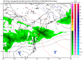
SUNDAY
The HIGH pressure area moves offshore, allowing warmer southwest winds to move in. But clouds could also move in during the afternoon.

Phila-sun to clouds. High 76. Chance of rain…20%
Shore-mostly sunny. High 68. Chance of rain 5%
MONDAY-MEMORIAL DAY
This day has the highest chance of rain, but also will be the warmest of the weekend.
Phila- mostly cloudy and warm. High 82. Chance of showers 50%
Shore-mostly cloudy and warm. High 75. Chance of showers 40%
More updates will come during the week…….
