
TRULY FROM THE BEYOND THE ARCTIC
This is what we mean when we say that our air is “coming from the Arctic”. Actually, in this case, it’s coming from beyond the Arctic. Our air can be traced back across the North Pole all the way to Siberia. Here’s the evidence:
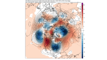
I’ve shown similar maps in the past, but they haven’t been nearly as extreme as this one. We’re looking at an upper-level map (around 20,000 ft.). Winds at that level tend to follow the lines on the map. So we can start in Philadelphia and trace that line back. It goes through Minneapolis and then back through Canada, across the North Pole, and then to Siberia. THIS IS NOT AN EXAGGERATION-IT IS THE “TRAJECTORY” of at least a part of the air that’s going to arrive this weekend. A flow like this has been called the “Siberian Express” in the past.
HOW COLD?
It’s not just about how low the temperature will go. It will be windy, too, so the wind chill will more closely represent just how cold it will feel to exposed skin. First, for the temps:
This is what the ground temperatures should be Sunday morning, Valentine’s Day (according to one computer model). First is a map of all of North America, and then a closer version with some actual numbers:
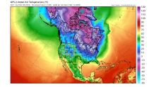
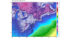
Remember, those are temperatures, not wind chills. A temperature of 5 degrees with a mere 10 mph wind equals a chill of -10 degrees. A 20 mph wind would make the wind chill -15. In parts of New England, temps will be -10 to -20, with wind chills reaching -30 to -40 degrees. Ouch!!!!
Local
Breaking news and the stories that matter to your neighborhood.

WILL RECORDS FALL?
The record lows for Philadelphia are 3 degrees for Saturday and 2 degrees for Sunday. It’s interesting that the Saturday record was last tied in 1983-another year with a strong El Nino.
The key to record cold in winter is snow cover. Usually, it takes a significant layer of white to reflect sunlight back into space. Since there will be only a little, patchy snow around, the records may not be broken in Philadelphia. But other places that will have snow on the ground have a chance.
As of now, we’re predicting lows of:
|
| SATURDAY | SUNDAY |
| PHILADELPHIA | 8 | 4 |
| ALLENTOWN | 4 | 1 |
| READING | 5 | 2 |
| ATLANTIC CITY | 11 | 8 |
| WILMINGTON | 8 | 4 |
| TRENTON | 8 | 4 |
| MILLVILLE | 9 | 6 |
(The Saturday low temperature might be late in the evening, near midnight)
WILL IT LAST?
In a word, no. This pattern is only temporary, and we’ll see a BIG warmup next week. That won’t be the end of Arctic air for the winter. There could be another round of the “Siberian Express” later in the month.
Glenn “Hurricane” Schwartz
Chief Meteorologist, NBC10 Philadelphia
