
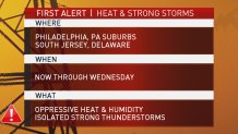
What to Know
- A First Alert is in effect through Wednesday night due to oppressive heat, humidity and scattered storms.
- Temperatures Tuesday will be in the 90s but feel closer to 100.
- People should take extra steps to stay cool and pay attention to young children, the elderly and pets.
Another scorching heat wave has descended upon the Philadelphia region, bringing dangerously high humidity, triple-digit feels-like temperatures and isolated strong storms.
A First Alert for muggy heat and scattered storms lasts through Wednesday evening for the entire region. The humidity is making the already high temperatures feel even more oppressive.
The muggy meter through Thursday remains at the oppressive level, which could fuel storms, First Alert Weather meteorologist Bill Henley said. Strong to severe isolated thunderstorms are a concern as the mugginess builds Tuesday as temps top out in the 90s.
The storms, however, could be less widespread Tuesday than they were on Monday, but shouldn't be ruled out. An isolated downpour could hit later in the afternoon.
Feels-like temps should push toward triple digits on Tuesday, but not quite as hot as Monday when the feels-like hit 105 in some neighborhoods. Wednesday will cool off slightly, but the humidity will still be high, along with the feels-like temperatures hovering in the mid to upper 90s.
Local
Breaking news and the stories that matter to your neighborhood.
The hottest time of the day will be from around 10 a.m. to 3 to 4 p.m., First Alert Weather meteorologist Steve Sosna said. Due to the urban heat island effect, in which buildings and concrete retain heat, some of the most oppressive conditions will be felt in urban areas. "It will probably be a good five to seven degrees warmer in the urban areas, especially at night," Sosna said.
The heat will pose a threat to everyone, so people should remember to stay hydrated (drinking mostly water and keeping alcohol to a minimum), avoid prolonged periods of direct sun exposure and reapply sunscreen every few hours.
Keeping your body cool will be key. You can take a cool shower or find a pool. If you don't have air conditioning, you can look for a place like a shopping center, library or movie theater that does. People should also leave windows at least slightly cracked to allow air to recirculate inside their homes, Sosna said.
"It's important to give your body a break because the heat adds extra stress because your body is working harder to cool itself off," Sosna said.
Extra precautions should be taken for young children, the elderly and pets.
The latest heat wave is the fifth of the season and is being caused by heat from the southern part of the U.S. moving north, Sosna said. In Philadelphia, the highest temperature resulting from the heat waves has been 98 degrees, while the highest feels-like temperature has been 110 degrees.
Once the heat breaks after Thursday, more comfortable and mostly clear conditions are expected through the weekend with plenty of sunshine and highs around 80.
For the latest on the heat wave, tune into the NBC10 News First Alert Weather Team on air and download our app to be prepared for the pop-up storms.
