The New Year is beginning soggy. Gray skies and on-off showers will continue throughout the region Monday afternoon and evening, as well as Tuesday. Wednesday will act as a transitional day, before cooler air filters into the region and high temperatures take a nosedive.
Wet But Warm Beginning to Week
Rain began falling across the region in the early hours of Monday, with some spots sitting below the freezing mark. As a result, a Freezing Rain Advisory was in place for parts of the region early in the morning. The changeover to primarily rain was quick through all zones except the Lehigh Valley and Berks County.
Highs in the low to mid 40s were seen Monday, but temperatures will actually plateau through the night into Tuesday morning. So, lows in Philadelphia Tuesday morning will not even drop into the 30s and instead will start warmer than the average high for this time of year (41 degrees). By Tuesday afternoon the temperatures will climb to the upper 40s. Low 50s are possible near the shore.
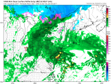
The moisture push from the southwest allowed for continued rain to fall on and off across the region, especially over New Jersey and Delaware through Monday afternoon and some light spotty rain is possible overnight. The rain may break altogether briefly overnight, but will return with the next round of rain moving in from the southwest. Here’s a look at one model prediction for 5 a.m. Tuesday indicating early light rain:
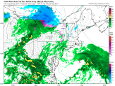
By the end of the morning commute, around 8-9 a.m., rain may become more steady to even heavy moving from southwest to northeast. In addition, the day will be gray and soggy again. Through the early afternoon, pockets of heavier rain are still possible. There’s a slightly higher potential for heavy rain in portions of Delaware and South Jersey. Take a look at the image below:
The steadier rain will move out in the later afternoon and early evening. Some lingering light rain may stick after sunset, but dry out overnight into Wednesday.
Shifting to a Colder January
Wednesday will act as a transitional day. Conditions will be drying out, and temperatures will peak in the first half of the day and then begin to fall due to a cold front passage. Highs are expected in the in the low 50s. Winds will also be stronger, with gusts between 25-30 mph. The winds will continue overnight Wednesday and into Thursday as well.
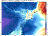
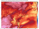
Once the colder air behind the front moves in, temperatures will drop. Thursday high temperatures will only move into the mid to upper-30s. Take a look at the comparison between the temperature anomaly maps from Tuesday afternoon and Thursday afternoon:
A polar air mass will sink across the area, which will keep temperatures near or below freezing each afternoon Friday through Monday. In fact, this weekend temperatures may never climb above freezing (even in the middle of the afternoon!).
With cold enough air, models are pulling a system into the region that could produce snow. Right now, they are not in agreement with the strength or timing of the system. That means there is still some uncertainty on its actual path and the impact we’ll see. Currently, the NBC10 First Alert Weather Team is calling for a chance of snow showers Friday. This will continue to be monitored and updated over the next several days.