

Superstorm Sandy became the worst natural disaster in history for our part of the country. It was a massive storm that eventually struck New Jersey, and covered a larger area than any one on record.
That size was one of the ingredients that made it so damaging.
The wreckage added up to $70 billion in the United States, and the storm took a path that is still being investigated seven years later.
HURRICANE SANDY'S LEFT TURN
Perhaps the most unique thing about Sandy was the virtually unprecedented left turn that it took while far off the East Coast. Storms well off the North Carolina coast almost always move out to sea or perhaps straight north into New England.
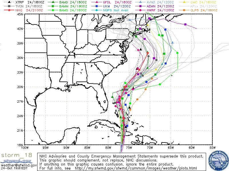
Despite the rarity of the left turn, some computer models made incredibly accurate forecasts of the track. Below is a map of many models (a "spaghetti plot") while Sandy was still in the Caribbean.

The left turn was best predicted by the European computer model. It was probably the most dramatic example of the overall superiority of that model. At the same time the EURO predicted the left turn, the U.S. main model, called the GFS, was predicting a right turn out to sea.
[[526008741, C]]
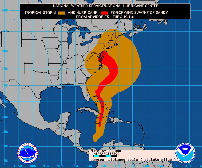
The left turn led to a direct hit on the New Jersey coast. This is a "worst-case scenario," where a perpendicular hit causes the highest storm surges. And with the giant size of the storm, the east winds around the storm stretched for 1,000 miles or more. That led the ocean to build more and more, leading to record storm-surge flooding in North Jersey and the New York City area.

WHY THE LEFT TURN?
It takes an unusual weather pattern to cause an unusual storm track. The key to that pattern (shown below) was a massive HIGH pressure in the North Atlantic, near Greenland. It helped create a "block" that prevented Sandy from going out to sea, or even continuing northward.
A CLIMATE CHANGE CONNECTION?
Local
Breaking news and the stories that matter to your neighborhood.


Climate change did not create Sandy. It probably would have formed just like it did in the Caribbean if it developed in a similar pattern 50 years ago.
But the size, intensification in the Atlantic, and the left turn are all valid subjects to investigate. Whenever we see weather events that have never happened in recorded weather history, it is natural to look at how the changing climate could have played a role.
I have been especially interested in that sharp left turn. That "blocking HIGH" near Greenland has been more common (and stronger) in recent years. This has been tied to the massive melting of Arctic ice, creating a pattern called "Arctic Amplification." Dr. Jennifer Francis of Rutgers University has been a leading researcher on this subject. Here is one example.
Am I saying with confidence that climate change caused the left turn? No. But I look at meteorologists as "weather detectives," searching for reasons for unusual weather patterns. And climate change is one of my top "suspects."
FUTURE SANDY-TYPE STORMS?
As unusual as Sandy was, there is no reason to assume this won’t happen again. Storms are already becoming larger and intensifying faster than even a few decades ago. And blocking patterns across the Arctic should continue to become stronger and more common.
It would still take a rare combination of weather factors to create another Sandy-type storm. Perhaps the next one will turn more quickly or sharply and make that direct hit into Delaware and South Jersey, areas that were spared the worst of the storm in 2012. Don’t let anyone tell you that it can’t happen again.

![[NATL] Activist Thunberg Declines Climate Prize, Urges More Action](https://ots.nbcwpshield.com/wp-content/uploads/2019/09/pride_jipsy_010.jpg?fit=722%2C513)
![[NATL] Pledges for Global Climate Fund Reach $9.8 Billion](https://ots.nbcwpshield.com/wp-content/uploads/2019/09/SCCD10.jpg?fit=288%2C432)